Mainly, there are 6 major physiographic or physical divisions of India. Physiography is defined as the outcome of structure, process, and stage of development.
About India
India is on the Asian continent. It is the 7the largest country in the world, area-wise, and 2nd biggest population-wise (2011 census).
India has a great diversity in terms of its physical features. the lofty Himalayas in the north, the great Indian Desert in the West and the Indian ocean in the south. India apart from the mainland has some groups of islands too.
The total geographical area of India is 3.28 million square km.
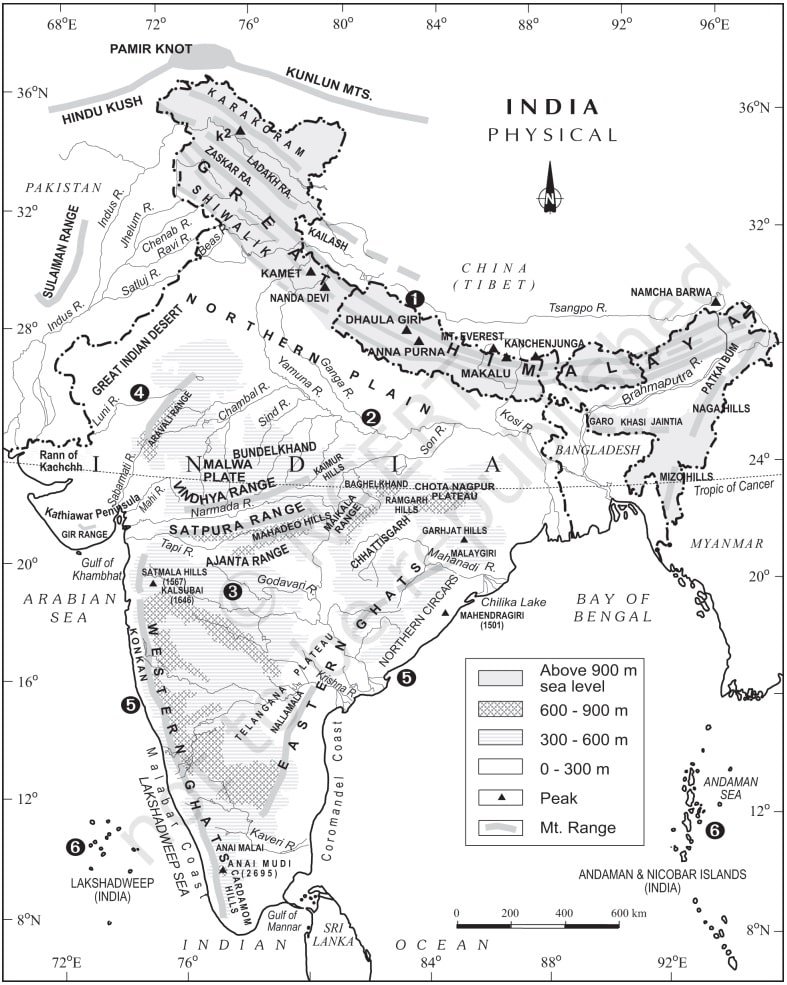
India can be divided into following 6 physical divisions:
- The Northern and North-eastern Mountains
- The Northern Plain
- The Peninsular Plateau
- The Indian Desert
- The Coastal Plains
- The Islands.
The Northern and Northeastern Mountains
The Himalayas and the Northeastern hills come under this region. The Himalayas are not only a physical barrier for the entire Indian subcontinent but they also act as a climatic, drainage and cultural divide.
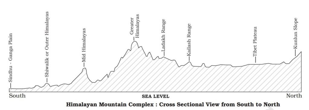
They consist of a series of mountain ranges. Some of the important ones from north to south are
- Greater Himalayas or Himadri also includes Great Himalayas and Trans Himalayan ranges.
- The Middle Himalayas or Himachal
- The Shiwaliks
Location and Size of Himalayas
The Himalayas are in the continent of Asia. They extend in India, China, Pakistan, Nepal, Bhutan, Afganistan, etc. Structurally, Himalayas are fold, young mountains.
The approximate length of the Himalayas is 2500 km east-west direction. The width ranges between 160 km to 400 km.
Most of the highest peaks in the world are in the Himalayas. The average height is about 6000 meters. The elevation of the highest peak in the world, Mount Everest is 8848 meters.
India’s highest peak in the Himalayas, Kanchenjunga has 8586 meters. Kanchenjunga also known as Mount K2 is at the border of Nepal and Sikkim.
Orientation of Himalayas
The table given below will give you some idea about orientation of the Himalayas in India:
| Location | Orientation |
| North Western Himalayas | Northwest to Southeast |
| Around Darjiling and Sikkim | East-West direction |
| Arunachal Pradesh | Southwest to Northeast |
| In Nagaland, Manipur, Mizoram, etc. | North-South direction |
Please refer to the physical division of India map given above for a clear understanding of the orientation of Himalayas.
Major Sub-Division of Himalayas
The Himalayas have large regional variations. Their sub-division on the basis of orientation, relief, and other geomorphological features:
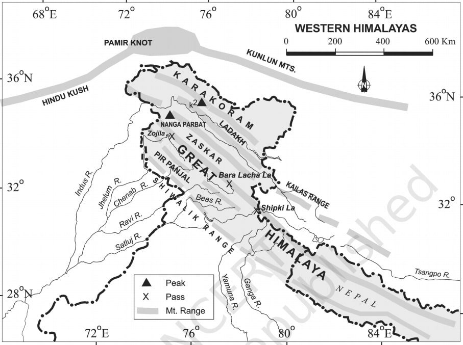
1. Kashmir or Northwestern Himalayas
- Karakoram, Ladakh, Zaskar and Pir Panjal ranges, etc. lie in the Northwestern Himalayas.
- The northeastern part of these Himalayas is a Cold Desert which lies between the Karakoram ranges and Greater Himalayas, and between the Greater Himalayas and Pir Panjal is the famous valley of Kashmir and Dal lake.
- Important glaciers of Asia such as Baltoro and Siachen can be located in this region.
- Important Passes in this region: Zoji La (Great Himalayas), Banihal (Pir Panjal), Photu La (Zaskar), Khardung La (Ladakh).
- Some of the important freshwater lakes are Wuler and Dal and Saltwater lakes are Pangong Tso and Tso Moriri.
- This region is drained by the Indus and its tributaries like Jhelum and Chenab.
- Famous places of pilgrimage in this region are Vaishno Devi, Amarnath Cave, Charar-e-Sharif, etc.
- The southern part of this region has longitudinal valleys called Duns, for example, Jammu and Pathankot Duns.
- This region is famous for Karewa formations, which are useful for the cultivation of Zafran (a local variety of Saffron).
2. Himachal and Uttaranchal Himalayas
- This region lies between the Ravi and Kali rivers. and drained by two major river system, that is the Indus and the Ganga.
- Major tributaries are the Ravi, the Beas and the Satluj of the Indus system, and the Yamuna and Ghaghara of the Ganga system.
- The northernmost part of this region is an extension of the Ladakh cold desert, which lies in the district of Lahul and Spiti.
- Some of the important places such as Dharamshala, Mussoorie, Shimla, Kausani, Kasauli, Almora, etc. are in this region.
- This region also has Duns such as Chandigarh-Kalka dun, Nalagarh dun, Dehra dun, Harike dun, etc.
- Some of the important places of pilgrimage such as the Gangotri, Yamunotri, Kedarnath, Badrinath and Hemkund Sahib are in this region.
- This region also has the five famous Prayags i.e. Devprayag, Rudraprayag, Karnaprayag, Nandaprayag and Vishnuprayag.
3. The Darjiling and Sikkim Himalayas
This region lies between the Nepal Himalayas and the Bhutan Himalayas. It is very small in comparison to other sub-divisions. High mountain peaks like Kanchenjunga and deep valleys resides here.
Lepcha tribes live here in northern part and the southern part is inhabited by a mixed population of Nepalis, Bengalis, and other central Indian tribes.
These Himalayas along with Arunachal Himalayas has an absence of Shiwalik formation. rather they have duar formation. hence, these are important for the development of tea gardens.
4. The Arunachal Himalayas
- This region extends from east of the Bhutan Himalayas to the Diphu pass (Arunachal Pradesh – tripoint of China-India-Burma).
- The general direction of this region is from Southwest to the northeast.
- Some of the important mountain peaks of this region are Kangtu and Namcha Barwa.
- Some of the important rivers of this region are the Kameng, the Subansiri, the Dihang, the Dibang, and the Lohit.
- This sub-division has a high potential for hydro-electric power.
- Some of the important tribes of this region are the Monpa, Abor, Mishmi, Nyishi and Nagas.
- Most of the people here practice Jhumming cultivation which is also known as Shifting or slash and burn agriculture.
5. The Eastern Hills and Mountains
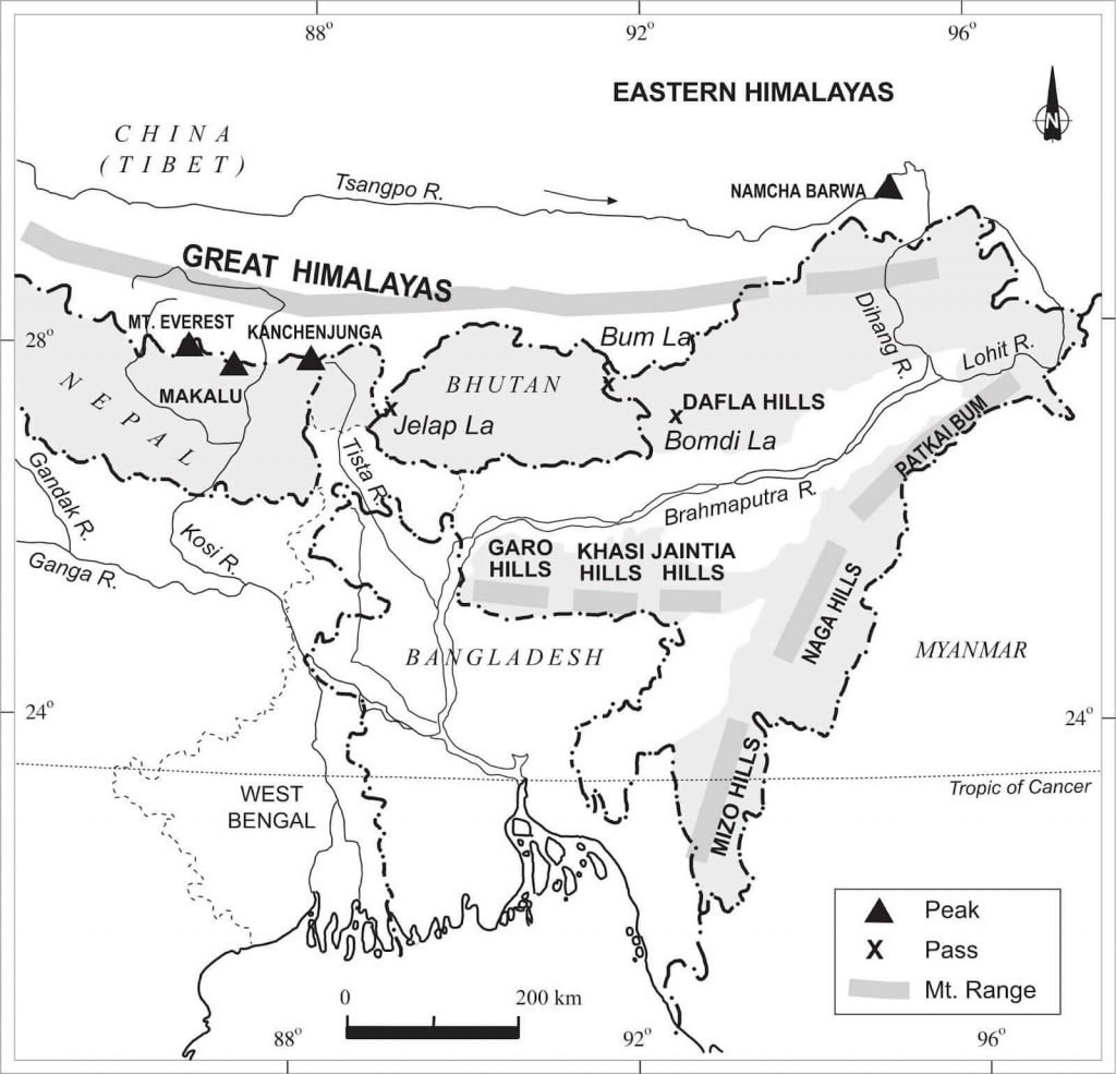
- These Himalayas are in the north-south direction.
- They have their local names in different regions such as Patkai Bum, Naga hills, the Manipur hills, and Mizo or Lushai hills.
- People in these areas practice Jhum cultivation too.
- Loktak Lake in Manipur is in this region. Mizoram is known as the Molasses basin.
The Northern Plains (Physical division of India)
The Indus, the Ganga, and the Brahmaputra made the Northern plains by depositing alluvial deposits.
| Length from east to west | ~ 3200 km |
| average width | varies between 150 – 300 km |
| maximum depth of alluvial deposit | 1000 – 2000 km |
The Northern plains can be divided into three zones from north to south, the Bhabar, the Tarai and the alluvial plains. The alluvial plains are further divided into the Khadar and the Bhangar.
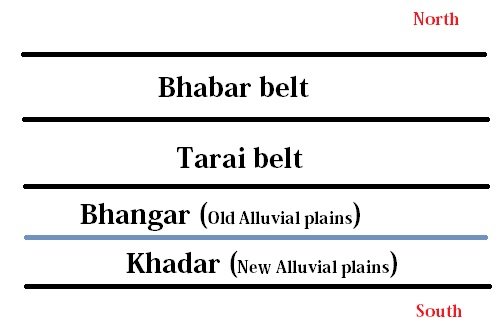
The Bhabar & Tarai belt
This region is a narrow belt parallel to the Shiwalik foothills. The width of this belt ranges from 8 to 10 km.
The river streams from mountains deposit heavy materials of rocks and boulders in this region. as a result, at times, they disappear here.
South of the Bhabar lies the Tarai belt. The approximate width of the Tarai region is 10-20 km.
After disappearing in the Bhabar belt, most of the river streams re-emerge in this belt. These rivers re-emerge without having any clearly demarcated channel. therefore, they create marshy and swampy conditions, which intern called Tarai.
The Alluvial Plains
This region consists of the Bhangar and Khadar belt. they are old and new alluvial deposits respectively.
In this region, the river creates depositional landforms such as sand bars, ox-bow lakes, braided channels.
These plains are fertile plains and support a variety of crops like rice, wheat, jute, sugarcane, etc. Most of this region is also prone to flooding.
The Peninsular Plateau division of India
This division is one of the oldest and stable landmasses of India. The slope of this region is towards the Bay of Bengal. in other words, the western part is higher than the eastern part. as a result, most of the rivers of the peninsular plateau are west flowing.
landforms demarcating the boundary of Peninsular plateau:
- Delhi ridge(extension of Aravalis) in the northwest.
- The Rajmahal hills in the East
- Gir ranges in the west and
- The cardamom hills in the south
However, the Shillong and Karbi Anglong plateau is also an extension of this in northeastern India.
Peninsular India is made up of lava plateaus such as the Hazaribagh, Palamu, Ranchi, Malwa, Coimbatore, Karnataka plateau, etc.
The peninsular plateau has undergone a series of upliftment and submergence. hence, crustal faulting and fracturing such as the Bhima fault (associated with seismic activities).
The Peninsular plateau can be divided into three groups, namely:
- The Deccan Plateau,
- The Central Highlands and
- The Northeastern Plateau.
The Deccan Plateau
Bordered by the Satpura, Maikal ranges and Mahadeo hills in the north, the Western Ghats in the west and the Eastern Ghats in the east.
The Western Ghats has some local names such as Sahyadri in Maharashtra, Nilgiri hills in Karnataka and Tamil Nadu, Anaimalai hills and Cardamom hills in Kerala. The Eastern Ghats are also known as Purva Ghats and Mahendra Pravata.
The average elevation of Western ghats is about 1500 meters while for the Eastern Ghats, it is about 900 meters with the height increasing from north to south.
The highest peaks of Peninsular plateau lies in the Western Ghats such as Anaimudu (2,695 m, Anaimalai hills) and Dodabetta (2,637 m, Nilgiri hills).
Most of the peninsular rivers rise from western ghats such as the Mahanadi, Kaveri, Godavari, Krishna, etc.
The Eastern Ghats are discontinuous and highly eroded low hills. Some of the important ranges of Eastern Ghats are the Javadi hills in Tamil Nadu, the Palconda range and the Nallamala hills in Andhra Pradesh, the Mahendragiri hills in Odisha, etc.
The Central Highlands
- The general elevation of Central Highlands is between 700 – 1000 m.
- The slope is towards the north and northeastern side. in other words, their height is less on that side.
- This region extends up to Jaisalmer in Rajasthan.
- Some of the important highlands are the Vindhyas and Kaimur ranges, the Rajmahal hills and the Chotanagpur plateau, etc.
- The Chotanagpur plateau has a large reserve of mineral resources.
The Northeastern Plateau
The Northeastern Plateau region consists of the Meghalaya plateau and Karbi Anglong plateau (Assam). It is believed that this region is the extension of the main peninsular. but, due to the movement of Indian plate in the northeastward direction, at the time of Himalayan origin, they got detached.
The Meghalaya plateau is further divided into three:
- The Garo Hills,
- The Khasi Hills and
- The Jaintia Hills
These names were given after the tribes living in those regions. The Meghalaya plateau is also rich in mineral resources like coal, iron ore, sillimanite, uranium, and limestone.
This region receives the highest amount of rainfall in comparison to other parts of India.
The Great Indian Desert or the Thar Desert
The Great Indian Desert lies to the northwest of the Aravali hills. This region receives rainfall of less than 150 mm per year. hence, it has an arid climate and sparse vegetation cover.
This is also known as Marusthali. The longitudinal sand dunes and barchans are some of the important desert landforms.
The underlying rocks of the Thar desert is an extension of the peninsular plateau.
On the basis of their orientation, this desert can be divided into two parts:
- The northern part which is sloping towards Sindh and
- The southern part is sloping towards the Rann of Kachchh.
Most of the rivers in this region are not perennial like Luni. The Deserty physiographic division of India is a water deficit region and also prone to droughts.
The Coastal Plains of India
The coastline of mainland India is about 6,100 km long. The Coastal plains can be broadly divided into two: (1) the Western coastal plains and (2) the Eastern coastal plains.
The Western Coastal Plains
The western coastal plains are submerged plains. because of this submergence, they are narrow belts. hence, provide natural conditions for the development of ports and harbors.
Western coastal plains are narrow in the middle and broader at the south and north.
Some of the important ports and harbors in this region are Kandla, Mazagaon, JLN port, Marmagao, Cochin, etc.
The Western coast has following divisions from north to south:
- The Kuchchh and Kathiawar coast in Gujrat,
- Konkan coast in Maharashtra,
- Goan coast in Karnataka and
- Malabar coast in Kerala.
The Eastern Coastal Plains
These are emergent coastal plains and are broader than the Western coastal plains. The continental shelf of these plains extends as far as 500 km into the sea. hence, the development of ports and harbors is difficult over here.
Unlike the Western Coastal Plains, the river in the Eastern coastal plains forms deltas.
Kolkata, Paradip, Visakhapatnam and Channai are some of the ports in the Eastern coastal plains.
The Islands of India
The Coastline of Islands in India is about 1197 km. India has two major groups of Islands – (1) The Andaman and Nicobar Islands, (2) the Lakshadweep island.
The Andaman and Nicobar Island groups
- Andaman and Nicobar Islands lie in the Bay of Bengal and consist of about 572 islands or islets.
- They are between 6 – 14 degrees N and 92 – 94 degrees E.
- The Andaman is in the north and the Nicobar is in the south. they are separated by the Ten-degree channel.
- Barren Island, the only active volcano of India is situated in Nicobar Island.
- Coral deposits are also found in these islands.
Lakshadweep and Minicoy Island
- These islands are in Arabian sea, situated between 8 N – 12 N and 71 E – 74 E.
- The distance between the Lakshadweep Islands and Kerala coast is about 280 to 480 km.
- This island group consists of around 36 islands of which Minicoy is the largest one (453 sq. km).
- The whole of these islands are made up of coral deposits.
- Some of the important name to remember are: the Canannore, the Amini Island, etc.
The Physiography divisions of India are such as they have almost all the type of landforms that we can found anywhere in the world. Please refer the maps seriously because they help in remembering the things easily.
Also read: